Where to Stop, Stretch, Snack, and Sightsee along Highway 17
You’re on the road between Ottawa and Mattawa when that familiar urge hits you. Whether it’s hunger, your legs need a break, or another urgent need is making itself known, one thing is sure; you can’t ignore muscle pangs forever. So take breaks often to ward off cramps and fatigue.
I’ve had the pleasure of visiting a variety of pit stops over the years. This time, I returned to Highway 17, enjoying rest areas, restrooms, scenic locations, and hiking trails, all in the name of research and road trip blogs.
Lucky for you, from Arnprior to Deux Riviere, this section of the Ottawa Valley has many options. Whether you need a walk to restore blood flow, a foodie stop to satisfy road trip cravings, or when nature’s call is difficult to ignore, this list is for you.

The accessible signed bathrooms in my list are at the following locations: Haley Station, Cobden Tourist Information, Pembroke Waterfront Park, Petawawa Rest Area, Meilleurs Bay Picnic Area, and Gibson Lake Rest Area/Mosquito Trail.
Only two of the main stops in my list lack basic facilities, and I’ll point them out.
Rest Stop, Haley Station
Sometimes, that last cup of caffeine before starting the road trip runs through me quicker than I’d hoped, so this little pull-off always comes as a relief and is never a minute too soon. The Rest Stop near Haley Station is about an hour from Ottawa, complete with basic facilities and one covered picnic area with panoramic views of the farm fields. There isn’t room for even a tiny stroll, so lean on your vehicle, stretch your legs, and then continue your journey.

- 110 km to Ottawa < 186 km to Mattawa
- If you were hoping for a longer walk, use this rest stop, then proceed to Cobden Marsh Interpretive Trail, which has no facilities.
- The picturesque village of Cobden has a few foodie options, and it’s 6.6 km away on Highway 17 West. If you’re looking for caffeine top-up and baked goods, try The Little Coffee Shop on Main Street.
Cobden Marsh Interpretive Trail, Forester Falls
Cross the boardwalk and walk around Cobden Marsh on raised gravel-topped berms, keeping the trails high and dry. The route circles the marsh, a provincially significant wetland with plenty of opportunities to observe wildlife in its natural habitat. I didn’t explore the entire trail, but I’d guess the Cobden Marsh Interpretive Trail is no longer than 1.5 km if the loop is still intact. At least if you come to a dead end, walking back around the wetland will be a flat-out breeze.

- 115 km to Ottawa < 181 km to Mattawa
- There are no facilities available at Cobden Marsh. Five kilometres on Highway 17 East is the Rest Stop in Haley Station, and the Cobden Tourist Information Center is 1 km away on Highway 17 West.
- Park in the gravel lot across from the trail on Forester Road.
- Do you love food trucks? Long summer walks pair well with chip trucks, and you’re in luck because there’s the Chip Pit in Cobden!
Veterans Memorial Park & Cobden Tourist Information, Cobden
There are plenty of picnic tables for relaxing and a small playground structure for kids in the Veterans Memorial Park. Stretch your legs; follow the walking path down to the lakefront and along the water to Cobden Beach for a pleasant stroll. Sitting and listening to the waves on the shores of Muskrat Lake is a wonderful way to unwind the stress of driving on Highway 17.

- 116 km from Ottawa < 180 km to Mattawa
- The rest stop at the Cobden Visitor Information Center is accessible with push-button door openers, running water and flush toilets, similar to the Pembroke Waterfront Park, the following location on my list.
- Head down Main Street to Sour Jo’s Sourdough Bakery for sandwiches, bread, baked goods, and more. Eat in or take some deliciousness to go.
Pembroke Waterfront Park, Pembroke
A mere 4.8 km off Highway 17 is the Pembroke Waterfront Park. There’s plenty of parking, a lovely boardwalk along the waterfront and expansive views of the Ottawa River and L’Ile-Aux-Alumette, QC., across the water. A welcome breeze comes off the river, and with the numerous park benches at the riverside, there are plenty of spots to rest, relax and recharge before continuing your road trip.

- 148 to Ottawa < 152 to Mattawa
- Located at this park are accessible bathrooms, running water and flush toilets. The only other spot with these luxuries is the Cobden Visitor Information Center, the previous location mentioned in my list.
- Get some seriously delicious food truck staples from Cheerful Harlies, located by the marina. If you love poutines, don’t hesitate to order one! The deluxe dog is delicious, the burgers are BIG in size and flavour, plus the classic cheese curd and gravy poutine is divine. You can taste it when food is made with love. The only thing this foodie spot needs is a few more picnic tables!
Petawawa Rest Area, Petawawa
The Petawawa Rest Area, set in a stand of pines, is a small and picturesque rest stop I’ve used so often that I should be collecting frequent flyer miles for the visits. I love sitting under the trees in the dappled light at the picnic tables. I always feel recharged and refreshed after spending time at this forested pullover.
- 159 km to Ottawa > 137 km to Mattawa
- Are you feeling peckish? McGuire's Doughnuts is four kilometres away on Highway 17 West and 3.4 km into Petawawa. If you’re heading west, you must stop here because McGuire’s Doughnuts in Pembroke is too far away now! So, head into town and get a box of doughnuts - you’ll be happy you took this detour!
Riverbank Park, Deep River
A short and sweet single kilometre off Highway 17 is Riverbank Park, with superb views of the Ottawa River and the Laurentian Mountains on the Quebec side. When I was there in May, the scene and devoid of boats, but last year in September? The river was dotted with fishing vessels and pleasure cruisers - everybody was out enjoying the water.

- 193 km to Ottawa > 105 km to Mattawa
- There’s a port-o-potty near the parking adjacent to the soccer field, and if you should happen to walk from Riverbank Park to the Deep River Marina, you’ll find a second port-o-potty.
- Eat in or get takeout from Long Shots Sports Cafe. I’ve had their Potato Skins, the Nachos (fully loaded), the burger and fries, and the Bandito wrap. So far, it’s a tie between the burgers and Nachos for my favourite!
Meilleurs Bay Picnic Area, Meilleurs Bay
Meilleurs Bay Picnic Area is a pretty parkette tucked in the trees, and the water is visible through the greenery. It’s gorgeous. There’s lots of room to stretch, walk or even play a game of tag or kick the ball around if the kids have the energy to burn. While there, I played catch-me-if-you-can with black flies as a Canada Goose, and fledglings watched me in horror. I’m joking about the games, not the bugs. If you’ve travelled to or from Northern Ontario, you know biting insects are part of life. Besides, you no longer feel the sting once you've been bitten enough times.

- 206 km to Ottawa > 90.4 km to Mattawa
- If you were searching for a picnic area to enjoy your packed (or takeout) meals, this is one of my favourite places to stop and eat.
- I found the best pizza here. From Deep River to Deux Rivieres, all the locals agreed that Rolphton Motel and Restaurant makes the best pizza, which I can attest to. I can’t remember the last time I had a pizza this good - plus, the restaurant is only six kilometres on Highway 17 West from Reilly Bird.
Reilly Bird Nature Preserve, Meilleurs Bay
Will there be biting insects at Reilly Bird Nature Reserve? Yes, because warm-weather birdwatching and bugs go hand in hand. So pull on your bug net, and spray your repellent before the hike. For the best start in life, even adult birds that feast on seeds and nuts will catch protein-rich caterpillars, spiders, and other crawlies for their fledglings.
I had planned on hiking to the lookout while birding, but I took the wrong trail! I didn’t study the map well enough at the trailhead. The trails are well marked, so, in the end, I wasn’t lost, just confused.

- 206 km to Ottawa > 90.3 km to Mattawa
- No facilities are available at the Nature Preserve, but the Meilleurs Bay Picnic Area is only 1.6 km away.
- Five kilometres away on Highway 17 West is the NPD Lookout, a scenic pull-off with a limited view of the Laurentian Hills and the Nuclear Power Demonstration Reactor site on the Ottawa River below. There are no facilities, only bear-proof garbage bins at this stop.
- In case you missed it, Rolphton Motel and Restaurant makes the best pizza, and it’s 6 km away on Highway 17 West from the nature preserve.
Mackey Creek Boat Launch, Mackey
Like most boat launches, it's easy to miss if you’re not looking for the signage. There will be one brown and white sign of the boat launch symbol with an arrow indicating the upcoming turn, then one other at the turn. If you plan to pull in, start slowing and signal your intention because the turn-off is tight and sharp, pulling off onto a short gravel lane leading you to the launch and parkette.

If you plan to swim or launch a watercraft, motored or otherwise, please, be aware of the dangers in this region. Mackey Creek currents can be swift with its close proximity to nearby dams and spillways.
- 221 km from Ottawa > 75.5 km to Mattawa
- Vault toilets are available but are not signed as accessible.
- Around here, it’s slim pickings if you’re looking for a meal. Head to Rolphton Motel and Restaurant nine kilometres away on Highway 17 East. To buy road trip snacks, go west on Highway 17 for 9.2 km to find Yates General Store in Stonecliffe.
Driftwood Provincial Park, Mackey
Don’t forget to register for your Daily Vehicle Permit before heading into Driftwood Provincial Park to the end of the road. The small gravel parking is adjacent to the boat launch and dock, facing the parkette and beach. From here, choose your adventure! Have a picnic on the beachfront and look for driftwood, hike on the Oak Highland Trail, or both!
The beauty of this park, its trails, beachfront park and views make it a favourite stop of mine. Whenever I pass this way, I spend an hour listening to the waves, eating snacks and recharging my internal batteries before continuing the journey on Highway 17.

- 225 km from Ottawa > 73.5 km to Mattawa
- If you’ve forgotten something tasty or have eaten the road snacks already, pick up cold drinks, ice creams, chips and other last-minute goodies from Driftwood Park Store. Never waste a chance to stock up when the opportunity presents itself on a road trip!
- If you just left the park, 7 kilometres away on Highway 17 West is Yates General Store in Stonecliffe.
Gibson Lake Rest Area / Mosquito Trail, Deux Rivieres
The Gibson Lake Rest Area is a beautiful and scenic stop. I take breaks here for a stretch every time I pass this way. Picnic tables, with views of the water and Jack pines, make me feel like I’m on the edge of the northern wilderness - not next to a busy highway. At this point of your road trip, you’ve probably noticed the signs that say “Take a Break. Fatigue Kills.” And it’s true, so I use all the rest stops available to stay fresh and alert while I drive.

- 253 km to Ottawa > 43 km to Mattawa
- If you’re heading west, you may regret not eating something at Rolphton’s by now, and it’s 41 km away. Around here, you have only a few options regarding food stops, so don’t miss Antler's Kingfisher Lodge’s convenience shop, 9 km on Highway 17 West. If you're heading in the opposite direction, 23.4 km on Highway 17 East is Yates General Store in Stonecliffe.
Lacroix Municipal Park, Deux Riviere
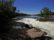
I almost missed this Historic Site on the Ottawa River, but I had it marked on my map this time, so I didn’t drive past the Lacroix Municipal Park and Boat Launch. There’s a Heritage Plaque about how “some of the river’s most spectacular and dangerous rapids were located immediately downriver from here: [...] the construction of the Des Joachims generating station, [the rapids] had been submerged in the dam’s headpond, Holden Lake.”
This section of the Ottawa River is one of the calmest for paddlers to explore. However, it still commands respect and humility - it’s a mighty river, and the currents can carry away the careless adventurer.

- 262 km to Ottawa > 34.5 km to Mattawa
- Vault toilets are available but are not signed as accessible.
- Get those last-minute items and snacks at Antler’s Kingfisher Lodge, less than 1 km away on Highway 17 East. Jamie and Jarrett have a small convenience store where you’ll find chips, chocolates and even Jones’ soda, my favourite!
Where Are You Headed Next?
I love road trips on familiar routes and heading down unknown roads, but I need to know where there are convenient rest stops to ease my journey. Check out my blogs Highway 60, Highway 62, or Highway 7 if you’re driving those routes in Ontario’s Highlands. Find out more of my favourite spots and insider tips!
Storyteller: