Best Highway 60 Hikes
So, you’re ready to hit the road. The King’s Highway 60 is calling your name - and who could blame you? The vistas on this route are stunning, from the Ottawa Valley to the Madawaska Valley. Every kilometre is a captivating experience.
It may seem like you could cruise forever on this roadway, but everyone needs to stop for a stretch every once in a while! After exploring Highway 60, from Renfrew to South Algonquin, I found some beautiful places for you to rest and restore your energy.
The Swinging Bridge at O’Brien Park
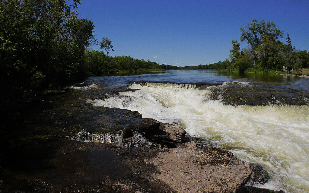
To feel the Swinging Bridge bob and sway under every step as you cross over the Bonnechere River, will be a highlight for many people at O’Brien Park. This modern reconstruction of the original suspension bridge (built in 1885) is a wonderful attraction in the heart of Renfrew.
After traversing the bridge, take the time to walk the premises around McDougall Mill Museum. This beautiful stone structure sits just below Bonnechere River’s picturesque Second Chute waterfall. Originally used as a grist mill (built in 1855), the building’s three floors now display many artifacts depicting the town’s early years, thanks to its restoration in 1969.
- Loop around Second Chute, 950m, easy. Cross the swinging bridge, walk up Raglan St. N to Stewart St. (Highway 60), across the bridge, and return on Arthur Ave.
- No facilities are available. McDougall Mill Museum is currently closed.
- A cheeseburger and fries satisfied my cravings at the drive-thru food truck, Odie’s Kingburger, in Renfrew.
Scenic Detour to the Fourth Chute
Take a scenic detour on Fourth Chute Road, off Highway 60, to discover Bonnechere River’s Fourth Chute Parkette. One could easily spend a day enjoying all the sights and sounds at this gem.
North of the road, there are two paths to explore either side of the river and the first waterfall. You can hear and feel the power of the churning water as the river flows through the bottleneck. On the southeast side of the bridge, there are more trails following the river. The paths are well worn, making the way easy to follow through the brush to lookouts on rocky ledges with a view of the fast-moving water below, or, descending into the gorge to walk on rocks at the river’s edge.
- There are two short paths north of the road, 25-50m long. South of the road is a single, linear main trail with multiple branching paths, approximately 450m to the first trail descending to the river. The way is unmarked, so you’ll have to investigate each one to discover what’s at the end of the path!
- Watch your step! Use care close to cliff edges, be careful of the cracks between the stones, and slippery rocks near the river.
- Facilities (by donation) are available at Bonnechere Caves.
John Egan Geo-Heritage Walking Trail
Ready to walk through geological history? Head to John Egan Geo-Heritage Walking Trail to explore the network of interconnecting trails. Take a self-guided tour of various rock types, river views, a trench that digs back in time, and a personal highlight for me - fossil hunting in the Ordovician Fossil Capital of Canada.
- Hard copies of the trail map are only available at Bonnechere Museum.
- There are multiple interconnected, linear trails at this Geo-Heritage site, it’s an estimated 1.5km walk to the fossil bed, the river lookout, and to return to the trailhead. I didn’t have a trail map on me, and trying to retrace my steps was tricky, but all paths eventually lead back to the CPR railbed. Keep the river to your left (you can hear it, even if you can’t see it) to return to the trailhead.
- There is an easy walking trail leading to Bonnechere Museum, passing through Eganville Centennial Park, crossing a pedestrian-only suspension bridge, that’s approximately 750m one-way. Find the details on the trail map linked below.
- Stay on the trails to avoid Poison Ivy and Poison Parsnip. There are notices posted along the trail.
- Learn more about fossils, and Bonnechere River history, visit the Bonnechere Museum.
Golden Lake Parkette
This park is a slim slice of land that hugs the water’s edge with picnic tables, and a panoramic view of Golden Lake. It’s a great place to relax, no matter what time you are passing by. There’s a little sandy beach so you can dip your toes in - or go for a swim. The Golden Lake Parkette is a hidden treasure, not found on Google Maps, but I included it on our custom Highway 60 Map!
- Facilities are available.
- Visit Deacon Escarpment if you’re looking for wilderness immersion! Lace-up your hikers, get your bug repellant and grab a map in the parking lot before exploring 30km of interconnecting trails. I suggest the Lookout Trail, a moderately difficult 1.5km linear trail (3km return), leading to a beautiful view of the escarpment and Golden Lake. A Day Pass is required.
Killaloe Station Park
Killaloe Station Park stands where the Old Killaloe Railway Station once stood. Two grey brick stripes run through the red brick path to mark the steel tracks of J.R.Booth’s railway that once ran through Killaloe.
The final passenger service through the town was in 1962. Walking the symbolic railway path, you can almost hear the train’s ghost whistle coming through the covered bridge - and the lost echoes of a once-bustling railway station.
- Water St. to Station Park west trail, 3.9km, linear - 8km return, easy
- Station Park east trail, 950m linear - 2km return, easy. Signage on the covered bridge indicated the east trail was currently closed.
- Killaloe is the birthplace of the Beavertail, and there’s a Beavertails location just a few steps from Station Park! Get your sweet (or savoury) fix before continuing on your journey.
Water Tower Park in Barry’s Bay
Diagonally across the street from Barry’s Bay Visitor Center is Ontario’s second last wooden trail Water Tower, standing tall in Water Tower Park. (link-16) Take the time to admire the workmanship of this beautiful piece of history. As you wander around the park, you’ll see more outdoor exhibits in the railway collection, a tribute to the Booth Line and railway history in Barry’s Bay and the region.
Don’t forget to visit the Visitor Center - it’s an original J.R.Booth style train station and the last left in existence.
- It’s an easy 500m walk through Water Tower Park, and around the Visitor Center.
- Facilities are available at the Visitor Center, with an accessibility ramp.
- Barry’s Bay is pedestrian-friendly, with many courtesy crosswalks throughout the town.
- West of the Visitor Center is Zurakowski Park honouring a local resident and test pilot, Janusz Zurakowski.
- At Barry’s Bay Public Beach, there are 3km of paved waterfront trails.
- My coffee and sandwiches were so good at Madawaska Coffee Co. Cafe in Barry’s Bay that I ordered a second time!
Roadside Park by the Opeongo River
This parkette is a beautiful little rest stop located just north of where the Madawaska River meets the river, near the J.R.Booth Heritage Railway Trail (link-19), which runs to Wilno’s Polish Kashub Park. Once you drive into the Roadside Park and round the first little bend, the highway disappears from view.
The picnic tables are well separated, so each spot has a private slice of nature. Walking around the dirt road loop is a great way to stretch the legs and admire the tall trees. If you look closely, you’ll spot the worn trails leading down to the water’s edge. I found a little sandy beach while following one of the paths down to the river!
- Approximately 850m walk around the parkette’s dirt road loop
- Facilities are available.
- Select picnic table sites have wide-open spaces that are perfect for kids to run around.
Taking to the Highway
No matter where your plans take you on Highway 60, make sure to enjoy the scenery, take breaks to stretch your legs regularly - and grab a bite to eat before continuing on your journey!
Storyteller:


